Cloud-Based Drone Mapping vs. Desktop-Only Workflows: Which Suits Your Project?
Understanding the Two Approaches to Orthomosaic Processing
When you capture aerial imagery with a drone, the raw images need to be stitched together into a single, geometrically corrected composite called an orthomosaic. This process, known as orthomosaic processing, is the foundation for most drone surveying and mapping projects. How you handle that processing depends largely on the tools you choose. Two broad categories have emerged: cloud-based platforms that handle computation remotely, and desktop-only workflows that run entirely on your local machine. Each approach has distinct strengths and weaknesses, and the right choice depends on factors like project size, turnaround time, hardware budget, and how you intend to share the results.
Cloud-based drone mapping services have grown rapidly in recent years. They allow you to upload your images to a remote server, where powerful processors stitch them together, often in minutes or hours, depending on the dataset size. Desktop software, by contrast, requires you to install and run the processing application on your own computer, using its CPU and GPU to complete the work. Both can produce high-quality orthomosaics, but the path you take affects everything from upfront costs to collaboration possibilities.
When Cloud-Based Mapping Shines
Cloud-based platforms are particularly well suited for large projects. If you are covering hundreds of acres or more, the sheer number of images can overwhelm even a high-end desktop computer. Uploading those images to a cloud server shifts the heavy processing load away from your local hardware. This means you can work from a relatively modest laptop and still generate detailed orthomosaics, digital surface models, and point clouds.
Another advantage is speed. Cloud servers are often equipped with specialized graphics cards and parallel processing capabilities that far exceed a typical desktop. A job that might take your local machine several hours to process could finish on the cloud in a fraction of that time. For projects with tight deadlines, this can be a game-changer. You can fly the site, upload the data, and have a processed orthomosaic ready for review before the end of the same day.
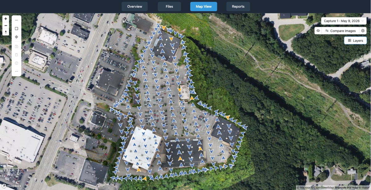
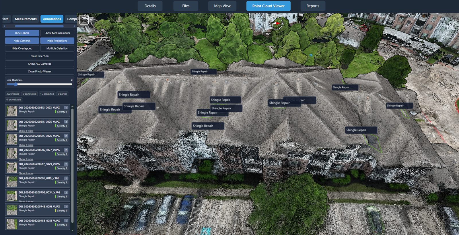
Collaboration is also easier in the cloud. Once the orthomosaic is processed, you can share a link with clients, project managers, or field teams. They can view the full-resolution image, take measurements, and add annotations without needing to install any software. This is especially valuable when stakeholders are spread across different locations or when you need rapid feedback.
Cloud platforms also handle storage and organization. Your data lives on the service's servers, so you do not need to manage large files on your own drives. Many platforms provide tools for comparing different flights over the same area, tracking changes over time, and generating reports. This can simplify workflows for ongoing monitoring projects, such as construction progress inspections or environmental surveys.
However, cloud-based processing does require a stable, reasonably fast internet connection. Uploading several gigabytes of images can take time, especially in areas with poor connectivity. If you are working in remote locations or on sites with limited bandwidth, the upload phase might offset the speed gains from cloud processing. There is also a subscription cost, which may be a recurring expense that some users prefer to avoid.
Desktop-Only Workflows: Control and Privacy
Desktop software puts full control in your hands. You process data entirely on your own machine, with no reliance on internet connectivity or third-party servers. This can be a major advantage for sensitive projects where data cannot leave your possession. Government, defense, and certain commercial clients often require that raw imagery and processed outputs remain on local systems.
For smaller projects, desktop processing can be perfectly adequate. If you are mapping a few acres with a manageable number of images, the time difference between cloud and local processing may be negligible. You avoid the upload wait entirely, and you can start processing immediately after the flight. There is also no ongoing subscription fee beyond the initial software purchase, which can be more economical over time if you process data regularly.
Desktop workflows also give you fine-grained control over processing parameters. You can adjust tie points, manually refine alignment, and troubleshoot specific issues that might arise with challenging terrain or poor overlap. Some experienced users prefer this level of hands-on tuning, especially for complex projects where the automated cloud pipeline might not produce the desired result.
The main drawback is hardware dependency. Processing large datasets on a desktop can push a computer to its limits. You may need a powerful graphics card, plenty of RAM, and fast storage to avoid long processing times or crashes. This hardware investment can be significant. Additionally, sharing results often involves manually exporting files and sending them via email, file transfer services, or physical drives, which can be cumbersome compared to a cloud link.
Mixing Both Approaches
Many professionals find that a hybrid workflow works best. They use desktop software for initial quality checks and small projects, then switch to cloud processing for larger or time-sensitive jobs. Some cloud platforms even offer a hybrid model where you can process data locally but use cloud storage and visualization tools for sharing and collaboration. This flexibility allows you to match the tool to the task without committing entirely to one approach.
For example, a surveyor might process a small residential lot on a laptop using desktop software, but upload a large agricultural survey to the cloud for overnight processing. The next morning, they can review the orthomosaic on any device and share it with the client immediately. This combination leverages the strengths of both worlds: the speed and collaboration of the cloud, and the independence and control of the desktop.
Key Factors to Consider
When deciding between cloud-based and desktop-only orthomosaic processing, think about these points:
- Project size and frequency: Large or frequent projects benefit from cloud speed; small, occasional jobs may be fine on desktop.
- Hardware budget: If you already have a powerful computer, desktop software may be cost-effective. If not, cloud processing saves you from upgrading.
- Data sensitivity: For confidential data, desktop processing keeps everything local. For collaborative work, cloud platforms simplify sharing.
- Internet reliability: A slow or unreliable connection makes cloud uploads painful. Desktop workflows work offline.
- Turnaround time: When you need results fast, cloud servers often outpace local machines.
There is no single correct answer. The best approach depends on your specific needs, resources, and the nature of each project. Many drone service providers, such as National Drone Services, offer nationwide turnkey capture and processing options that combine cloud-based processing with professional data management, making it easier for clients to access processed orthomosaics without investing in hardware or software. This kind of service can be a practical middle ground for organizations that need high-quality results but prefer to outsource the technical workflow.
Ultimately, orthomosaic processing is a technical task that has become more accessible thanks to both cloud and desktop tools. Understanding the trade-offs allows you to choose the method that best fits your workflow, budget, and timeline. As drone technology continues to evolve, the line between cloud and desktop may blur further, but for now, each approach has a clear place in the surveyor's toolkit.
Whether you process on the cloud, on your desktop, or a mix of both, the goal remains the same: turning raw aerial images into accurate, actionable maps. The right choice is the one that gets you there efficiently and reliably for each unique project you take on. National Drone Services is one example of a provider that can help bridge the gap, offering a platform for uploading, processing, organizing, visualizing, comparing, measuring, and sharing drone aerial data on a national scale.
National Drone Services on social media
 Facebook